How commuters got to workplaces in Brisbane, 2006 and 2011

Sat 17 November, 2012

My last post about Brisbane journey to work focussed on where people live. This post focuses on where people work and what modes of transport they use to get there. It covers employment density, mode shares by work locations, and mode shares for people travelling to the CBD.

ABS data about mode shares at work place locations is available for Statistical Local Areas (SLA) in 2006, and for Statistical Area Level 2 (SA2) geography in 2011. These are the smallest available areas in each year, and unfortunately SLA level data was not available at the time of posting for 2011 (to enable a direct comparison on the same areas).

Fortunately for Brisbane, there is a lot of similarity between the two sets of boundaries (some SLAs split, some combined, some restructured).

The following maps alternate between 2006 and 2011 using the slightly different boundaries. You will need to click on them to enlarge and see the animation.

Caution is needed when making inferences when the geographies change as different areas will have different numbers of employees. For example: If two SLAs with 2% and 10% mode shares (in 2006) were combined into a new (2011) SA2 area with 11% mode share (in 2011), it doesn’t mean that mode share actually changed from 2% to 11% in the first of the SLAs. It may be that many more people were employed in the SLA with 10% mode share and actually very little changed overall.

Employment density

Firstly, what does the employment density of Brisbane look like? If I had the travel zone data available (as per Sydney), I’d be able to draw a much higher resolution picture, but for now I will have to suffice with SLA/SA2 employment density:

A lot of the differences you can see between 2006 and 2011 are to do with the change in boundaries, not necessarily changes on the ground. For example, there are many more SA2s than SLAs in the Ipswich area, which has meant the 2011 data shows a slightly dense area in the centre of Ipswich.

Some places where the SLA and SA2s are the same and a change in employment density is evident include reductions in New Farm, West End, Mitchelton, Wynnum, and Chermside West, and an increase in Enoggara.

Mode share by workplace location

I’ve zoomed in on the inner parts of Brisbane so you can see the inner city details for mode shares (apologies for the lack of place names – I figured the numbers showing the mode shares might be more interesting).

First up, public transport mode share:

Public transport mode share was highest in the CBD, then for areas around the CBD and stretching to a little more to the inner south-west. Curiously, public transport mode share was relatively high in suburban Carindale (the patch of yellow turned green in the “middle” eastern suburbs) and Nundah in the middle northern suburbs.

Significant rises in PT mode share were evident in the following places:

  • Fairfield/Dutton Park – which went from 7%/9% to 23%, which is probably related to the Boggo Road busway and green bridge and route 196 BUZ route.
  • Chelmer (6% to 12%) – perhaps related to train frequency upgrades on the line to Darra
  • Teneriffe (10% to 20%) – although it was absorbed into Newstead-Bowen Hills in 2011 the two SLAs combined into one SA2 had a similar number of employees in 2006. In 2011 Teneriffe was served by a new CityCat ferry terminal, and bus services were upgraded (including the CityGlider bus).
  • Kelvin Road – Herston, which went from 14%/16% to 21% (including the growing Kelvin Grove Urban Village and bolstered by the northern busway)

Next is active transport:

There was very little change in active transport mode share by destination. The exceptions were St Lucia (including University of Queensland) which increased from 13% to 16%, and Highgate Hill which went from 9% to 13%. These areas are connected by the new green bridge (buses, walkers and cyclists only) which would have made it easier to reach these places by active transport.

Enoggera records 13% in both 2006 and 2011, which is explained by the existence of a major army barracks there. I’m not sure why the Anstead area had a 15% mode share in 2006 (it was blended out in 2011 with the change of geography).

Finally, here is sustainable transport mode share (public transport + active only transport):

Suburban destinations with high sustainable transport mode share include:

  • Robertson (which includes Griffith University went from 13% to 17%)
  • Carindale (eastern suburbs, 14% to 17%)
  • Taigum/Fitzgibbon (north suburbs, steady 12%)
  • Mount Ommaney (south-western suburbs, 13% in 2006 but unclear in 2011 due to larger SA2)

The significant rises are covered by the discussion above.

Commuting to the CBD

The Central Business District (CBD) is an important destination as it has the highest employment density, and public transport is probably best placed to compete against the car. For this analysis I am defining the “CBD” as the Brisbane City SA2, which is bounded by Hale Street in the west, Wickham Terrace in the north, Boundary Street in the north-east, and the Brisbane River (here is a map). That’s probably bigger than what you might call the core CBD, but unfortunately I cannot obtain 2011 data at a smaller geography.

Brisbane’s CBD accounted for 15.5% of Greater Brisbane journey to work destinations in 2011, and 14.1% of Brisbane Statistical Division destinations in 2006 (Greater Brisbane is slightly larger than the Brisbane Statistical Division). There were 9.5% more journey to work destinations in the CBD in 2011 compared to 2006.

Here’s a map showing the proportion of commuters who had a destination of the Brisbane CBD in 2011 (by home location at SA1 geography):

The prevalence of the CBD as a work destination is almost directly proportional to the distance people live from the CBD, with the notable exception of Springfield in the southern suburbs.

The next map shows the portion of CBD commuters who used public transport in their journey to work (by home location). I’ve only shaded SA1s with 20 or more CBD commuters, which is quite small for calculating mode shares.

Note: I have not filtered SA1s by density on these maps (unlike others), so some low density SA1s to the south-west of the CBD are included in the following maps.

Public transport mode share was particularly high for those further from the CBD (where such a long drive would probably not be fun or cheap). It was lowest around the CBD itself (presumably the locals just walked to work), a few scattered suburban locations, and around the wealthy and low density Pullenvale area to the south-west (served only infrequently by public transport but not that far from the CBD).

Here’s the share of people who only used private motorised transport to commute to the CBD:

Pockets of high private motorised transport mode share include:

  • Hamilton/Albion
  • Bardon
  • Kenmore
  • Fig Tree Pocket
  • Capalaba
  • Gumdale
  • Tingalpa
  • Yeronga
  • Indooroopilly
  • Pullenvale

I understand that many of these are relatively wealthy areas.

Mode shift in journeys to the CBD

How have mode shares changed for journeys to work in the CBD?

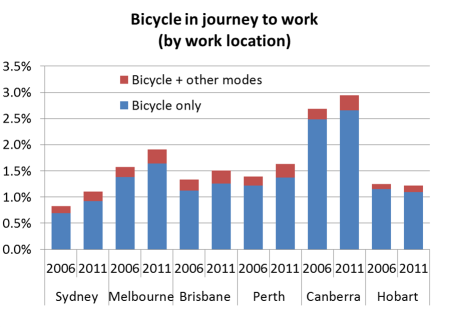
Public and active transport increased their mode shares considerably over the 10 years. In fact, the Brisbane CBD had the second highest mode shift to public transport (in percentage terms) of major Australian CBDs (behind Perth, more on that in a future post).

The absolute number of car driver trips fell from 26,397 in 2001 to 23,244 in 2011, while the number of public transport trips shot up from 47,208 in 2001 to 65,570 in 2011 – a 39% increase (a very similar increase to Melbourne and Adelaide). In the same time, South East Queensland public transport patronage grew by 59%.

The vast majority of people who used public transport to commute to the CBD only used one mode of public transport. However, the percentage of people using multiple public transport modes rose from 2.7% in 2001 to 2.9% in 2006 and 3.6% in 2011, suggesting integrated ticketing may be influencing public transport travel behaviour. That said, Brisbane’s CBD still had the lowest rate of multiple public transport mode journeys to work of the CBDs of Australia’s five biggest cities (more on that soon).


I’d like to acknowledge Jane Hornibrook for assistance with this post.


Spatial changes in Brisbane journey to work 2006-2011

Sun 4 November, 2012

How have mode shares of journeys to work from different home locations changed in Brisbane? What impact have recent bus service level improvements had?

In my post on city level mode share changes we saw that Brisbane had a 1.2% mode shift to public transport between 2006 and 2011. This post will uncover which areas shifted the most.

The following animations show various mode shares for journeys to work from census collection districts for 2006 and Statistical Area Level 1 (SA1) for 2011. These are the smallest geographies available for each census. All the data is by place of usual residence.

I’ve animated each image to alternate between 2006 and 2011, so you can gaze at them and spot the changes. You’ll need to click on them to enlarge and see the animation.

Public transport

You can mode shift in the inner suburbs, The Gap, the Albany Creek area, around Shorncliffe, the middle southern suburbs (between Yeerongpilly and Woodridge), and the strip towards Shailer Park. Much less mode shift is evident in the outer suburbs, particularly Ipswitch, Victoria Point, Cleveland, and Redcliffe. The Springfield growth area shows higher mode shares than average for urban fringe areas without heavy rail.

Sustainable transport (only)

This map excludes those who used private transport to reach public transport. In most outer suburbs of Brisbane, it seems the vast majority of people are using private motorised transport as part of their journey to work, including to get to train or busway stations.

Train

Significant mode shift can be seen along the Ferny Grove line, the Shorncliffe line, and the line towards Darra. I can see little mode shift on other lines.

There was modest mode shift towards train in the Inala area (near the Richlands rail line that opened in early 2011). Perhaps it will take some time for commuting patterns to change to take advantage of the rail line?

Note that a significant share of people in Springfield used trains. They will be getting a train closer to home when the rail line extension from Richlands to Springfield opens in 2014. It appears that only a few of them got to the train by feeder bus, as the next map shows.

Bus

There was significant shift to bus use in the southern suburbs, particularly around the South East Busway (shown in purple). This busway opened in 2001, but it seems mode shift has continued. There was also strong shift in South Brisbane and the West End (where the high frequency CityGlider bus was introduced), out to The Gap, to the inner south-west, the inner northern suburbs between the train lines, and south through Calamvale (north of Browns Plains, now served by high service “BUZ” bus routes using the South East Busway). There was little shift to using buses in the outer suburbs, other than in the Browns Plains area which is now serviced by BUZ routes.

Ferry

There are some significant changes, particularly around the West End (south-west of the CBD) where ferry mode share collapsed (perhaps due to increased bus service levels and disruptions to ferries following the 2011 floods). Ferry mode share also dropped in the St Lucia area, and for students on the University of Queensland campus. I suspect this might be to do with increased bus service levels.

There was strong growth in ferry mode share in Bulimba (north-east of the CBD), following the reopening of the Apollo Road Ferry Wharf in 2008 (which on these maps seems to have been a success) (Apollo Road wharf is the furthest downstream ferry wharf on the south bank).

Train and bus

Train and bus journeys increased share in many areas around Brisbane (note the different scale). Notable areas include around Ferny Grove, North Lakes, along the Beenleigh rail line, along the rail line to Darra, and in Springfield. However these are all very small mode shares.

Multiple public transport modes

Multiple public transport mode journey origins tend to be fairly scattered, so here is a summary over the Greater Brisbane area (using place of enumeration data and thus losing journeys with ferry + non PT modes):

Integrated fares were introduced in 2004/05 eliminating the fare penalty for changing modes. There was a slight drop in multi-modal public transport mode share in 2006 (compared to 2001), but then a substantial rise by 2011 (faster than growth in single mode journeys). I want to explore multi-modality in journey to work data some more soon. Stay tuned.

Mode shift to public transport overall

Here’s a map showing the overall mode share to public transport in Statistical Local Areas (SLAs), the smallest geography where data is available for both 2006 and 2011 (you’ll need to click to enlarge, and unfortunately my GIS software doesn’t give every SLA a label ).

The biggest mode shifts to public transport on this map are in Pallara – Heathwood – Larapinta (mostly sparsely populated), around Darra-Richlands (where the new train line opened), Calamvale (new BUZ routes presumably), and around the end of the South East Busway.

Pinjarra Hills has a shift but only 139 people travelled to work from this SLA in 2011, so it only takes a few people to register a larger mode shift. And before you get excited about the airport area (Pinenba-Eagle Farm), only 144 people travelled from there to work in 2011. I’ll look at mode share by work location in a later post.

The biggest shift away from public transport was in Yeerongpilly, whilst other SLAs with significant drops include Fairfield, Geebung, Holland Park, and Highgate Hill. Not sure what the reasons might be in those places.

Walking only

There was a slight shift to walking in the inner city areas, notably around Woolloongabba, Paddington, and Wilston. Walking mode share was highest around the CBD, Fortitude Valley, and around St Lucia/University of Queensland (UQ).

Cycling

Cycling has grown rapidly (off a small base), particularly in the inner suburbs include around St Lucia/UQ and West End.

I’m sure other people will find more patterns – please comment on any interesting finds.


Trends in journey to work mode shares in Australian cities to 2011

Tue 30 October, 2012

[updated December 2012 with more Canberra and Hobart data, and removing ‘method of travel not stated’ from all mode share calculations]

The ABS has just released census data for the 2011 journey to work (amongst other things). This post takes a city-level view of mode share trends.

Public transport

The following chart shows the public transport share for journeys to work for people within Statistical Divisions (up to 2006) and Greater Capital City Statistical Areas (for 2011) for each of the Australian major capital cities.

PT mode share trend

You can see 2011 increases in public transport more share in all cities except Adelaide, Hobart and Canberra. Melbourne grew by 2.2%, Perth by 2.1%, Sydney by 2.0%, Brisbane by 1.1% while Adelaide, Canberra and Hobart dropped by 0.1%.

But there are limitations of this data:

  • Census data is usually available by place of enumeration (where you actually were on census night) and/or place of usual residence. In the above chart the following years are by place of enumeration: 1991,  2001, 2006, 2011. I am just not sure whether the other years are place of enumeration or place of usual residence (ABS were unfortunately not as rigorous with their labelling of data tables in the past). There may be small differences in the results for place of usual residence.
  • The data available to me has been summarised in a “lossy” fashion when it comes to public transport mode share. It means that a journey involving tram or ferry and one or more non-PT modes is not counted as public transport in any of the results (it falls under “other two modes” or “other three modes” which includes PT and non PT journeys). For example, car + ferry or bicycle + tram. That means the true share of trips involving public transport will be slightly higher than the charts above, particularly for Melbourne and Sydney.
  • The 2011 figures relate to Greater Capital City Statistical Areas. For Perth, Melbourne, Adelaide, Brisbane and Hobart these are larger than the statistical divisions used for 2006 and early data. This means people on the fringe are now included, and they are likely to have lower rates of public transport use. So the underlying trends are likely to be higher growth in public transport mode share.

The limitations in counting of tram and ferry trips can be overcome by measuring mode share by workplace location, although I can only get such data for 2001, 2006 and 2011:

PT mode share by workplace trend

These figures are all higher because they include people travelling to work in the metropolitan areas from outside (where PT might have a higher mode share via rail networks for example) and they count all journeys involving ferry and tram. Between 2006 and 2011, Melbourne grew the fastest – by 2.4%, Sydney and Perth were up 2.0%, Brisbane up 1.2% and very little change in Adelaide, Canberra and Hobart.

Cycling

The following chart shows cycling only journey to work mode share:

cycling only mode share trend

(Adelaide and Perth are both on 1.3% in 2011)

Canberra is the stand-out city, owing to a good network of off-road bicycle paths through the city. But Melbourne has shown the fastest increase, going from 1.o% in 2001 to 1.6% in 2011.

Adelaide, Perth, Brisbane and Melbourne had a significant drop between 1991 and 1996, but this did not occur in Hobart, Canberra or Sydney.

Canberra, Melbourne and Sydney have shown the most growth in recent times. Adelaide and Hobart unfortunately went backwards in 2011. I’m not sure why Adelaide dropped so much, maybe it was a product of weather on the two census days?

Here’s another view that includes journeys with bicycle and other modes (by work location, not home location):

Bicycle any mode share

Perth and Canberra had the largest growth in journeys involving cycling and other modes.

Walking only

walking only mode share trend

Walking only rose in all cities 2001 to 2006, but then fell in most cities between 2006 and 2011 (Perth and Brisbane the exceptions). Perhaps surprisingly, Hobart had a higher rates of walking to work than all other cities.

Car

The following chart shows the proportion of journeys to work made by car only (either as driver or passenger):

car only mode share

(both Adelaide and Hobart were on 82.7% in 2011)

You can see car mode share peaked in 1996 in all cities except Canberra where it peaked in 2001, and Hobart where the 2011 result was just under the 1996 result.

Hobart, Adelaide and Canberra had small rises in 2011 (1.0%, 0.4% and 0.1% respectively) while Perth had the biggest drop in car mode share (down 2.6%), followed by Melbourne (down 2.0%), Sydney (down 1.8%) and Brisbane (down 0.9%).

Vehicle passenger

Vehicle passenger by work location

Travel as a vehicle passenger has declined in all cities, suggesting we are doing a lot less car pooling and commuter vehicle occupancy is continuing to decline in line with increasing car ownership. Curiously Hobart and Canberra topped the cities for vehicle passenger mode share.

Overall mode split

Because of the issue of under-counting of tram and ferry data for place of enumeration, I’ve constructed the following chart using place of work and a “main mode” summary:


work dest mode split 2001-2011

I assigned a ‘main mode’ based on a hierarchy as follows:

  • Any journey involving train is counted with the main mode as train
  • Any other journey involving bus is counted with the main mode as bus
  • Any other journey involving tram and/or ferry is counted as “PT Other”
  • Any other journey involving car as driver, truck or motorbike/scooter is counted as “vehicle driver”
  • Any other journey involving car as passenger or taxi is counted as “vehicle passenger

In future posts I plan to look at the change in spatial distribution of journey to work mode share (by home and work location).

I’d like to acknowledge Dr John Stone for assistance with historical journey to work data.


Traffic volumes on Australian toll roads

Sat 3 March, 2012

[Fully revised March 2020]

What are the trends in traffic volumes on major toll roads in Australian cities? How sensitive are motorists to toll prices? How accurate have traffic forecasts been? Are traffic volumes on toll roads growing faster than traffic in general?

This post aims to shed some light on these questions.

I have sourced traffic data from various sources, including Transurban ASX releases, annual reports, Transport for NSW, operator websites and media reports (I cannot guarantee error-free data gathering).

Average daily volumes

Firstly, here is a chart showing the average daily volumes for toll roads where I have been able to obtain data. Note that I have used a log scale on the Y-axis. The label includes the most recent volume figure available. For some roads and time periods only report annual figures are available (shown as dots rather than lines).

Interact with this data in Tableau.

How have growth rates changed over time?

The following charts show traffic volume growth since an early reference year, compared to BITRE estimates of total vehicle kms for each city:

Citylink volumes grew faster than general traffic for the first decade, but has been more in line with general traffic since then. You can see there are periods of suppressed demand, which very likely correlate with periods of major roadworks. After each period of roadworks, traffic volumes have rebounded strongly and shown further growth (probably eroding congestion reduction benefits). The underlying rate of growth appears to be declining.

It’s a little more difficult to construct a chart for Sydney as different lengths of history are available for different roads. I’ve anchored the chart at 2011:

Most toll roads have had traffic growing faster than general traffic in Sydney. Westlink M7 and Hills M2 have had the highest growth since 2011, with the M1 Eastern Distributor showing the least growth. You can see declines on the Hills M2 and M5 (presumably during roadworks) followed by significant growth as capacity was made available.

Not all of Brisbane’s toll roads have growth faster than overall traffic. Transurban report that AirportLink and Clem7 volumes have recently been impacted by upgrades on the Gateway motorway.

An important note on growth rate precision: Transurban report daily traffic volumes rounded to the nearest thousand. For roads with relatively small volumes (eg Clem7), the growth rates will be more impacted by rounding errors. For example, the traffic volumes on Clem7 went from 27+26+27+27=107 thousand in 2014/15 to 27+26+26+27=106 thousand in 2015/16, which is notional growth of -0.9%. But actual values for each quarter will be within +/-500, and the rounding errors will add up over the eight quarters making up the calculation. The actual growth could be anywhere between -4.6% and 2.9%, but is more likely to be in the middle of that range.

Unfortunately data isn’t always readily available:

  • The Brisbane Gateway Bridge and Logan/Gateway Motorway extension data is only available for financial years in annual reports up until 2010. Transurban took over these roads and have reported traffic volumes since 2013 but they do not appear to be comparable measures so I have listed them separately.
  • In October 2011, Horizon Roads purchased Melbourne’s Eastlink, and they do not seem to be publishing traffic volumes.
  • I haven’t been able to source Clem7 data for 2012 and the first half of 2013.

Traffic growth on other toll roads

Sydney Harbour Bridge and Tunnel

Calum Hutcheson from Hyder Consulting has generously compiled and shared time-series data with me on traffic volumes going back to 1971 for these two toll roads. He has sourced data from several available sources but has had to estimate some figures where data is missing.

Sydney Harbour Traffic 2

Traffic volumes levelled off on the bridge around 1988 and on the combined bridge and tunnel around 2005. It would appear the tunnel brought additional vehicle capacity good for around 17 years’ growth but that has now been exhausted (although I’m far from an expert in Sydney traffic). Traffic volumes on the tunnel have barely growth since 2010.

In 1992 one southbound lane of the bridge was converted to a bus lane (presumably related to the capacity freed up by the tunnel). The bridge’s vehicular traffic levels have not returned to 1988 levels, but I suspect the number of people moved in (road-based) vehicles has increased significantly (not to mention the train line across the bridge).

Sydney Cross City Tunnel

The Cross City Tunnel was forecast to carry 87,088 vehicles per day in 2006, but in 2019 was still less than half this amount.

I have not been able to source much data pre-2013, but a 2006 NSW Auditor General’s report contains some traffic volume data for 2005 and 2006, reproduced here (from page 32 of the report).

It would appear that motorists are highly sensitive to toll pricing, and the forecast volumes were not achieved even when tolls were removed.

Brisbane’s Clem7 cross-city tunnel

Brisbane’s first new road tunnel, the Clem7, opened in March 2010. During the first three weeks of toll-free operation, there was an average of 59,109 vehicles per day. During the first week of tolling, this fell to 20,602. The forecast was for initial traffic of around 60,000 vehicles per day, rising to 100,000 within 18 months. Owners at the time, Rivercity Motorways, went to the extraordinary step of publishing daily traffic data, as can be seen in the following chart showing traffic volumes since tolling commenced:

You can see an up-tick from the beginning of July 2010, when toll prices were cut. Tolls were raised in November 2010 and again in April 2011 and you can see corresponding drops in traffic volumes. Average daily traffic in calendar 2011 was 10% lower than for the first 12 months of operation (includes one overlapping quarter).

During the 2011 flood crisis tolls were waived for one week, and at the end of that period on Monday 17 January 2011, 40,566 vehicles were recorded, the highest since tolling commenced. This may or may not have also reflected closures to other roads making Clem7 more attractive. (footnote: actual weekend volumes have not been published for April 2010, so I have substituted the average non-workday figures, that have been published).

Traffic volumes on the Clem7 peaked at 30,000 in 2018, less than a third of the forecast for the year 2010.

Brisbane’s Airportlink

This toll road was forecast to attract 135,000 vehicles per day one month into operations, and have 165,000 vehicles per day after the ramp up period. Volumes in 2019 were around 63,000 – less than half the forecast after ramp up.

AirportLink traffic

The traffic volumes declined as tolls were progressively introduced to all traffic. BrisConnections, the owner of the road, went into voluntary administration in February 2013.

The Clem7 and Airportlink roads are the first two major tollways as part of the TransApex plan for adding major road capacity to Brisbane.

The third piece of this puzzle is the Go Between Bridge, now part-owned by Transurban and they report a flat 11,000 vehicles per day as of 2019. The forecast was for 17,500 by 2011 and 21,000 by 2021.

I’m guessing it may be a very long time before these TransApex roads reach capacity.

Eastlink

The following chart shows that Eastlink actual traffic volumes were fairly consistently around 60-65% of original (2004) forecast after tolling began. It suggests the forecasts were good at estimating the ramp-up shape, but not so much the overall traffic volumes.

Note: ConnectEast issued revised forecasts in August 2009, including that (steady state annual) average daily trips in 2011 would be 209,900. That forecast doesn’t appear to have been realised either. Unfortunately data reporting stopped in October 2011 following the sale to Horizon Roads.

Maps of Australian Toll Roads

Here are some rough Google maps: Melbourne Sydney Brisbane.
Maps and more information about many of the roads is also available on the Transurban website.

Other sources of traffic volume data

See another post on Melbourne traffic volumes. Some interesting recent data on Brisbane traffic volumes is in this report prepared for RiverCity Motorways (who operated the Clem7). It shows many major roads in Brisbane with stable or declining traffic volumes (possibly because they are at capacity, or possibly because of a mode shift to public transport).

New South Wales traffic data is available for selected locations, as well as detailed data for toll roads.

Victorian data for non-tolled roads is available here, but unfortunately does not include time series history.